

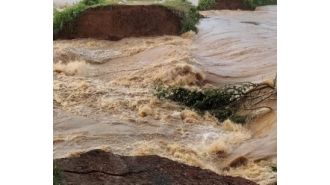
A recent map has been released, providing a glimpse into the potential future of 32 coastal cities in the US. The map, created by researchers at Virginia Tech, highlights the areas that could face inundation due to rising sea levels and sinking land. The cities in danger zones span across the Atlantic and Pacific coasts, as well as the Gulf of Mexico.
The study, which was published in Nature, utilized various data sources such as sea level rise projections, tide charts, and satellite measurements of land subsidence. The results were eye-opening, projecting that up to half a million Americans could be affected and one in every 35 private properties could experience flood damage within the next 30 years. Leonard Ohenhen, the lead author of the study and a graduate student at Virginia Tech, commented on the challenges of communicating the issue of sea-level rise and land subsidence.
He noted that many people tend to view it as a long-term problem that won't have any immediate impact. However, the researchers aimed to paint a more urgent picture by focusing on the short-term consequences - just 26 years from now. The study, released in early March, also revealed that 24 out of the 32 cities are currently sinking at a rate of more than 2 millimeters every year and a half.
This may not seem like much, but when combined with sea-level rise over time, it can have significant consequences. Ohenhen used a sinking boat analogy to further explain this concept - even a small amount of rain can cause the boat to sink faster than expected. The 131 flood control structures in the 32 cities are meant to provide some protection, but the map shows that they may not be enough.
Half of these structures are located on the California coast, leaving the Atlantic coast more vulnerable. Only three out of the 11 cities highlighted on the Atlantic coast have floodwalls or levees in place. One of the cities at highest risk of being swallowed by the ocean is Miami, Florida.
Experts predict that South Florida could lose around 80,000 homes and 122,000 residents could be at risk. The potential damage has been estimated at a staggering $31 billion. Socioeconomic and racial factors also come into play for some coastal cities, particularly those along the Gulf Coast.
The study found that cities such as New Orleans, Louisiana, and Port Arthur, Texas, could disproportionately impact racial minorities and properties with a lower value. Manoochehr Shirzaei, an associate professor involved in the study, emphasized the importance of the findings in informing future decisions. He stated that this may be the first comprehensive picture of what's to come in the not-too-distant future.
Thanks to this study, the public and decision-makers now have access to crucial data that can help shape plans and actions to mitigate the potential damage.
Flooding in Jajpur district, India due to 2 breaches in Kani River embankment. Residents taking shel...
Read More
Police in Odisha created a green corridor to transport a 10-year-old boy with a critical injury to a...
Read More
Recent conflict has caused a lot of strain....
Read More
Indian banks collected over Rs 7,000 crore in FY26 from minimum balance charges, with private sector...
Read More