November 29th 2024.
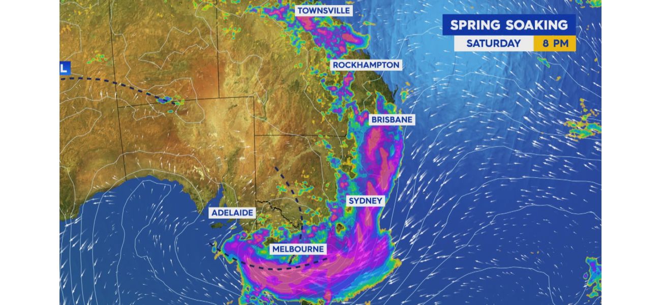
This morning, flood warnings have been issued for several states as the East Coast was hit with a series of thunderstorms overnight. The NSW State Emergency Service has been working tirelessly since the storms began on Thursday, responding to a staggering 584 incidents including fallen trees and leaking roofs.
Some parts of Sydney were also drenched with rain, causing concert-goers at the Domain to stand in ankle-deep water during Aussie DJ Dom Dollar's performance last night. In Melbourne, a tragic accident occurred when a man crashed into a supermarket overnight.
In NSW, the Hawkesbury-Nepean River catchments are currently under a minor flood warning. This warning also applies to the following areas: Colo River, Macdonald River, Castlereagh River, Macquarie River to Bathurst, Macquarie River downstream of Burrendong Dam, Bogan River, Lachlan River to Cotton's Weir, Mandagery Creek, Tumut River, Upper Murrumbidgee River to Burrinjuck Dam, Cooma Creek, and Queanbeyan and Molonglo Rivers. Additionally, there is minor to moderate flooding along the Belubula River.
Other states have also been affected by the storms, with flood warnings in place for parts of Queensland, Victoria, and Tasmania. In Queensland, there are also thunderstorm warnings for the Townsville Coast and inland areas. These warnings cover the Northern Goldfields and Upper Flinders, Herbert and Lower Burdekin, Central Coast and Whitsundays, Central Highlands and Coalfields, Maranoa and Warrego, and Darling Downs and Granite Belt Forecast Districts. Isolated thunderstorms and scattered showers are expected, which could lead to flash flooding in affected areas.
In the past six hours, Logan Creek has seen 102mm of rain, while Haughton Bridge was hit with 161mm. Moderate and minor flood warnings have been issued for various areas in Queensland, including the Bulloo River, Moonie River, Warrego River, Lower Barcoo River, Paroo River, and Upper Balonne River.
Victoria is also feeling the effects of the storm, with flood warnings for the Kiewra and Mitta Mitta Rivers. Gale winds are predicted to hit the East Gippsland Coast, while strong winds will impact the West, Central, and Central Gippsland Coast. These winds are expected to continue until Sunday.
Meanwhile, Tasmania is bracing for severe weather as well. Residents in the Furneaux Islands, North East, East Coast, North West Coast, and parts of Central North, Central Plateau, Western, and Midlands Forecast Districts have been issued severe weather warnings. The storm will bring heavy rainfall and damaging winds, and a Flood Watch warning is in place for the North, North West, North East, South East, and Derwent Catchments. It is important for residents to take precautions and stay safe during this time.
[This article has been trending online recently and has been generated with AI. Your feed is customized.]
[Generative AI is experimental.]